SpikeCamp Is Here: Every Wildfire on One Map, Built on the Fireline
SpikeCamp is live in early access. A free live map of every US wildfire, offline tactical maps, Meshtastic radio relay and crew tracking, built by a wildland firefighter for the places where the signal dies.

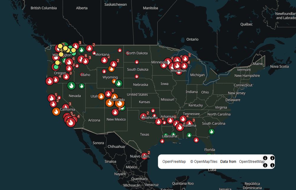
SpikeCamp is live. Open spikecamp.app and every active wildfire in the United States is right there on one map: perimeters, satellite hotspots, smoke, air quality, evacuation zones and the aircraft working the fire. Then take it into the backcountry, because SpikeCamp keeps working long after your phone loses its last bar.
This is early access, which means you get in first and you help steer what we build next. We ship new features every week, and we are just getting started.
Born on the fireline
SpikeCamp was built in Oroville, Washington, by the founder of Ultra Labs, an active wildland firefighter and former US Army field artillery officer, coming straight off the 2026 Sinlahekin Fire.
That season made the problem impossible to ignore. Crews squinting at downloaded PDF maps, trying to line up a blue GPS dot by hand. Crew slots and gear traded around on Facebook. Phones dead by midday. Hours of canyon with zero signal. So we built the tool we wanted on the line, with one rule above all others: it works with zero signal, and a connection is a bonus.
This is what Ultra Labs is about. Real experience on the ground tells us what matters. The latest technology lets us build it fast and build it right.
Every fire, one map, free
No account. No paywall on safety. As we put it on the site, "Safety info is always free." Open the map and you get:
- Live fire perimeters and incidents from the National Interagency Fire Center
- New starts straight from Washington dispatch centers, often before they hit the national feeds
- Satellite hotspots from NASA FIRMS
- Smoke from NOAA's Hazard Mapping System and air quality from EPA AirNow
- Evacuation zones for California, Oregon and Okanogan County, with more areas coming online
- Open shelters from FEMA
- Fire aircraft working near active fires
- Alerts for the places you care about, like home or your parents' town
Every fire gets its own page with its size and the latest map. Send it to family, send it to your neighbor, send it to anyone who needs to know whether it is time to pack the car.
Built for the places where signal dies
Every other fire app assumes you have a connection. SpikeCamp assumes you do not, and that changes everything.
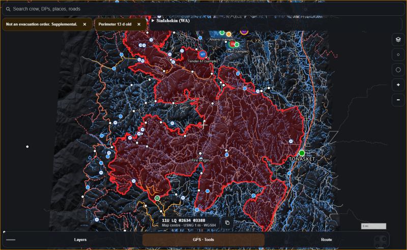
- Offline tactical maps. Grab the fire map while you have signal, and it is yours for the whole shift. Sinlahekin is the first full tactical pack, and more fires are on the way.
- Live GPS on the fire map. Your position, right on the tactical map. No more lining up a PDF by hand.
- Meshtastic radio relay. Crews carrying Meshtastic mesh radios share their positions with no cell service at all, passed radio to radio across the fire.
- Phone first, sync later. Everything saves on your device and syncs the moment any link shows up, from a cell tower to a Starlink Mini at camp.
- Tiny updates. Your phone pulls down only what changed, so it saves data and battery.
- Every fact shows its source and its age. You always know exactly how fresh your information is.
SpikeCamp installs straight from the website to your home screen. No app store, no waiting on reviews, and every fix reaches every phone in minutes.
Try the Sinlahekin map
This is the real tactical map from the Sinlahekin Fire, and it is yours to explore. Drag to pan, pinch to zoom, and tilt with two fingers or a right-drag to see the terrain rise up in 3D.
Open the live 3D Sinlahekin map
Built for crews
SpikeCamp is made for the people on the line. Signed-in crews get it all free during early access:
- Crew tracking with a simple join code
- An emergency button that puts your location in front of your crew
- A command board with the fire, perimeter, hotspots, aircraft and evacuation zones in one view
- Briefings and crew messaging
- Map feeds for TAK and other mapping tools, plus GPX export
Run a crew or work with an agency? Bring SpikeCamp to your next assignment and tell us what you need: ops@spikecamp.app.
Plans
The free map covers every bit of safety information above, and it stays free for good. SpikeCamp Pro launches soon at $5 a month or $48 a year, with more watched places, wind and weather layers, photo pins, a family check-in link, and full tactical maps with GPS.
What's next
We are moving fast. Coming up:
- Text messaging over the Meshtastic mesh
- More offline map areas
- Fuels and fire spread layers
- Apple Health, Garmin and Fitbit
- Native background tracking
- Breadcrumb trails and external GPS
Get in now at spikecamp.app and help shape it. The best ideas so far have come from the people closest to the fire.
Where the data comes from
SpikeCamp brings together public data from NASA FIRMS, EPA AirNow and its partner agencies (air quality data is preliminary), the National Weather Service, the National Interagency Fire Center, NOAA HMS, FEMA (ESF6-SS), CAL FIRE, Oregon OEM, Okanogan County GIS, local dispatch centers via WildCAD, USGS, the FAA and adsb.lol, with maps © OpenStreetMap contributors. None of these agencies endorse SpikeCamp, and SpikeCamp does not use Watch Duty data.
SpikeCamp is not an official or government alert service. While SpikeCamp does aggregate and parse news and alerts from a number of government/official sources, SpikeCamp itself does not dispatch assistance, and does not issue evacuation orders. Data may be delayed, incomplete, or inaccurate. GPS, offline maps, and mesh radios can fail. Call 911 for a life-safety emergency.
SpikeCamp is published by Ultra Labs LLC, a veteran-owned Washington company. See everything we build on the Ultra Labs brands page.